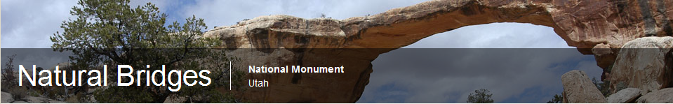
Utah's First National Monument
Three majestic natural bridges invite you to ponder the power
of water in a landscape usually defined by its absence. View them from
an overlook, or hit the trails and experience their grandeur from below.
Declared a National Monument in 1908, the bridges are named "Kachina,"
"Owachomo" and "Sipapu" in honor of the Native Americans that once made
this area their home.
There are literally hundreds of arches (bridges) throughout
southern Utah and northern Arizona. Then we came to the edge of Monument Valley
– literally at a precipice where even the road map shows an incredible number
of roadway switchbacks to reach the valley floor. We were driving along on
seemingly flat land then BOOM – we had to stop just to take in the several
thousand feet drop to the valley floor. But it was more than that. As far as
the eye could see, the valley went on and on with a monument or two popping up
here and there. As far as the eye could see – I’m talking hundreds of miles –
something had happened to the land millions of years ago. Where (in the world)
did it all go? So the monuments were made of sturdier material – fine. But for
heavens sake where did all that other dirt go to? Mexico? If so you can’t see
it from the road. It’s as though a huge shovel, with a blade about 100 miles
wide, just reached onto the earth and starting moving dirt. But I couldn’t tell
where.
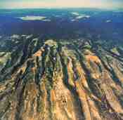
Colors
This map has more unusual colors than any equivalent in Indiana.
We spent the night in Blanding at the Prospector Motor Lodge. Stay here only if it's your last resort (humor) available. What looks like a mountain is actually huge depressions (valleys) throughout the area.
Natural Bridge
Typical deep gorge - the entire park is a series of deep gorges. Just don't get caught at the bottom when a rain storm comes through.
This is the Natural Arch - well photographed. More on
Natural Bridges formation.
A close up view shows how narrow one end is. Reportedly cowboys would ride their horses over the bridge at one time (but not now...)
Sipapu, a
Hopi word, is a small hole or indentation in the floor of
kivas used by the
Ancient Pueblo Peoples and modern-day
Puebloans. It symbolizes the portal through which their ancient ancestors
first emerged to enter the present world.
[1]
Kachina is "the middle bridge." Spanning the canyon equidistant from
both Owachomo and Sipapu bridges. It is larger than Owachomo but smaller
than Sipapu. Proving that canyons are dynamic rather than static,
approximately 4,000 tons of sandstone fell from the inside of the
Kachina bridge opening in June, 1992, enlarging the opening as it has
doubtless been enlarged time and time again.
Interesting arch formation. You can see where the water swirled around for, perhaps, millions of years.
The rivers swirls through this gorge after a heavy rainfall.
Did you know...
Pinyon pines do not produce pine nuts every year. These delicious nuts
can only be harvested every three to seven years. This irregular
schedule prevents animals from adapting to an abundance of pine nuts and
guarantees that at least some nuts will become new pine trees instead
of a quick meal.